Swiss Re’s Mohit Pande Reflects on 2020’s Record-Setting Hurricane Season and Why This Risk Could Get Even More Costly
Back in August, the Swiss Re Institute released an analysis of how hurricane risk preparedness has evolved since Hurricane Katrina made landfall in 2005. The report touches on several trends including climate change, growing populations in exposed coastal regions, and improvements in flood risk assessment.
Though many coastal cities have stepped up mitigation efforts, the report definitively states that hurricane risk is only continuing to rise: “This detailed examination of changes in New Orleans since Katrina illustrated the complex interplay between several risk trends, many of which point to a steadily increasing hurricane risk. Unfortunately, trends in hurricane exposure, vulnerability and hazard are not limited to only the New Orleans region.”
According to Mohit Pande, head of property underwriting in U.S. & Canada at Swiss Re, the 2020 hurricane season has underscored another key factor contributing to increased risk: the inadequacy of current probabilistic hurricane modeling.
Risk & Insurance® sat down with Pande to discuss trends in hurricane risk and why models are due for an update.
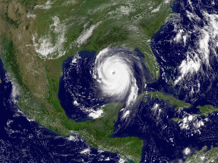
Risk & Insurance: How would you characterize this hurricane season in terms of storm frequency and severity? How does it compare to other highly active seasons?
Mohit Pande: It was a busy season, and we’re all very happy it has come to an end. Overall, there were 30 named storms, which is a record.
Twelve of those made landfall within the U.S. — another record. We saw the latest Category 5 with Hurricane Iota, which ultimately hit Central America as a Category 4 storm in November.

Mohit Pande, head of property underwriting, U.S. & Canada, Swiss Re
This season triggered approximately $20 billion in insurance claims, which is moderate compared to the record seasons we had in 2005 and 2017. It could have been worse if a major storm had hit a major population center. This year, insurance covered about 45% of global economic losses in 2020, which is above the 10-year average of 37%.
R&I: What are the chief flaws with insurers’ hurricane models that are causing the industry to underestimate this risk?
MP: The hurricane models have done a good job for the industry for several years to provide a consistent basis for pricing this risk from an aggregation control standpoint, and for purposes of risk and capital management.
But these models are only as good as the data and information we feed them. They need to constantly evolve to capture the latest scientific research, engineering studies and climate insights.
One thing that attracted a lot of industry attention 15 years ago that has not been on people’s minds recently is the Atlantic Multidecadal Oscillation (AMO), which is a natural climate signal that impacts the frequency of hurricanes in the North Atlantic.
For several years after the 2004-2005 seasons, the industry considered the impact of the AMO on hurricane activity by taking a shorter-term view of risk in their catastrophe loss modeling, which looks at annual to decadal climate patterns [and results in increased projected frequency of storm activity].
The industry has since switched back to a longer-term frequency perspective despite the AMO signal continuing to point to above average frequency of storms for some time to come.
There’s a strong need to increase awareness within the industry on the impact of short-term climate signals like AMO. Hopefully the hurricane activity from 2017 through 2020 has served as a proof point that despite the lull we saw between 2006 to 2016, the Atlantic Basin remains in an elevated frequency phase.
The good news is that since we raised this point in our 15-year Katrina report, I’ve received a number of communications from industry colleagues who agree with it.
R&I: Can you give us a high-level explanation of the Atlantic Multidecadal Oscillation (AMO) and its impact on hurricane activity?
MP: To put it simply, we have more hurricanes during the “warm” phase of the AMO when sea surface temperatures are higher than average and atmospheric conditions are more conducive to hurricanes. Conversely, hurricane activity decreases in the “cold” phase.
It’s a multidecadal oscillation, which means each phase can last for several decades, and it’s hard for us to tell when it will shift. If you look at old AMO data, a phase will typically last anywhere from 25 to 40 years.
The AMO index has remained positive since the mid-1990, which corresponds to high activity at the basin-wide scale, and we have not seen any indication at this point that is shifting back to cold.
R&I: What other trends are contributing to increased hurricane risk beyond storm frequency and severity, and do models adequately account for these?
MP: Population growth in more exposed coastal areas is one of the factors driving loss trends that we are currently witnessing, and the models do factor this in to some extent.
However, you learn new things every time a hurricane makes landfall in any environment, but particularly in an urban environment where the interaction of the hurricane and the exposures can be quite complex. For example, most models were not capturing risk of levee breach pre-Katrina, and now they do a much better job of measuring that.
The important thing is our industry must continually innovate the way it assesses risk, along with its consequences and cost. Outdated models and historical loss data are no longer reliable enough.
In addition to the traditional sources of data like HURDAT (a catalog of all tropical cyclone events going back to 1800s compiled by the National Hurricane Center of NOAA), models should incorporate the latest scientific and engineering research. When it comes to assessment of exposures, the methods start to get a little more proprietary.
R&I: What changes would more accurate models drive in the way that re/insurers price hurricane risk and manage their portfolio?
MP: Our role as insurers and reinsurers is ultimately to pay claims and help communities to rebuild and bounce back after a loss. To do that, we must manage the potential impact of hurricanes on our own portfolio, reserves and capital.
If we are consistently misjudging the risk through inadequate frequency or severity views, then it becomes difficult for us to play that role effectively. &